
Best Hiking Trails In & Around McCall, Idaho
The Best Rental Cabins, Homes, Lakefront Estates and Romantic Getaways in McCall, Donnelly, Cascade & New Meadows
The natural beauty of Central Idaho is truly breathtaking. For this reason, hiking is one of the most popular activities in the McCall area, which is located about 100 miles north of Boise.
Outdoor enthusiasts can find more than 500 miles of public trails, 300 lakes, and 1,400 miles of streams in the McCall area. Some of the most well-known lakes are Payette Lake and Lake Cascade. Notable rivers in the area include the Payette River, Salmon River, and Snake River.
Hiking trails are available for all levels of fitness and any timeframe. If you only have an hour or would like to hike all day long there are some great options. String together a longer trip in the Payette National Forest for backpacking. There are many places to camp and many miles of trails in the backcountry.
Summer is also when you’ll see many mountain bikers out in the natural surroundings, and during the winter months, snowshoeing and cross-country skiing are available on many of the trails which makes the outdoors accessible to residents year-round.
The beautiful scenery around McCall includes high mountain lakes, fields of wildflowers, and mature trees. Each hike offers something different and many unique experiences await hikers. Here is a look at some of the most popular McCall Idaho hikes.
– Distance: 10.5 miles
– Type of trail: Out & back
– Difficulty: Moderate
– Location: Northeast of McCall, Idaho
Secesh (Delta Mist, Whangdoodle) Hot Springs is an 8-mile out-and-back trail located near McCall, ID that features hot springs. The trail is good for all skill levels and is primarily used for hiking. Secesh Hot Springs lies way above the Secesh River and requires a quarter mile, near vertical hike to reach after the river Ford. Hot water from the source flows directly into the top pool. The outflow from the top pool and two other smaller sources fill the subsequent pools below. The 3rd pool from the top (just below the 2nd) isn’t warm or deep enough for a soak. The last and lowest pool, located all the way down by the Secesh River features frigid, stagnant water.
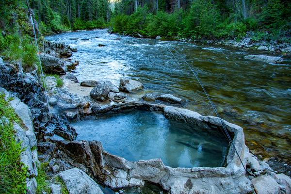
Photo Credit: CSNafzger
– Type of trail: Out & back
– Difficulty: Easy
– Location: Forest Road 474, Idaho, USA
This route includes Blackmare Lake. A sylvan soak in the South Fork Salmon River Canyon hidden below a paved road. Skinny-dippable with discretion. A crystal-clear soaking pool, well concealed from the nearby road, sits at the base of a steep bank on the river’s edge. It’s enclosed by attractive chunks of stream rock mortared tightly in place. A large slab at one end makes a backrest for enjoying the view up the tree-studded canyon. Spring water, cooling from 115 degrees F as it trickles down the bank, can be diverted by means of a long pipe. Locals refer to this spot as Mile-16 because of its strategic location on the road. It’s also known as Sugah, Fire Crew, and Holdover.
– Distance: 12 miles
– Type of trail: Loop
– Difficulty: Challenging
– Location: National Forest Road 080, McCall, ID 83638
Loon Lake Loop and Beyond is a 10-mile loop trail located near Riggins, ID. The trail is rated as moderate and primarily used for hiking. Two scenic Canyons and a large, productive lake. The trail to Loon Lake is usually done as a loop. In the past, however, the big question was whether one could ford the Secesh River because it was not bridged at Chinook Campground, and because it is a river, not a creek. Finally, in the fall of 2000, the Forest Service built a pack bridge over the Secesh to protect the Chinook salmon that spawn in and near this very location.
Photo Credit: Arne Beruldsen
– Distance: 3 miles
– Type of trail: Out & back
– Difficulty: Moderate
Unlike most trails that gain elevation, this one starts at 5760′ and drops to 5080′. Hikers must be ready to walk uphill on the way back. The first part of the trail goes steadily downhill to Goose Creek Bridge, which is not recommended for small children. At this point, the trail meets a junction with Goose Creek Trail (Trail #353). If you continue a quarter of a mile farther, you will be greeted with a dramatic view of Goose Creek Falls.
Start your journey to the trailhead from McCall and go north on Highway 55 for five miles. Turn right on Goose Lake Road/Forest Road #257. Head toward the Brundage Mountain Ski Resort. About three miles north from there, you will find the Gordon Titus Parking Area. The trail departs from this parking lot.
Photo Credit: Michael R Richardson
– Distance: 3 miles
– Type of trail: Out & back
– Difficulty: Moderate
Twin Lakes (Trail #165) is a steady, one-mile, uphill climb to the Twin Lakes. The elevation gain is only about 400′. You can fish at the top, but it’s best to go early in the season because of the drawdown at the dam. Bring the whole family and have a picnic at the top, it’s a fun place for kids.
If you would like to make the hike longer, veer off the trail at the half-mile mark and climb to Granite Mountain. It’s a challenging hike but offers a rewarding view.
To find the trailhead, go north on Highway 55 and turn right on Goose Lake Road. Stay left as Brundage Mountain Resort draws near. The road turns to dirt. When you get to a Y junction, keep left toward Hazard Lake on Forest Service Road 247. In about seven miles, you will see a sign for “Granite Mountain/Twin Lakes Trailhead” on your left. Note that there are no restroom facilities at the trailhead.
– Distance: 3.8 miles
– Type of trail: Out & back
– Difficulty: Easy
– Location: The trailhead is located at the Forest Service campground at Hazard Lake.
The hike to Hazard Lakes (Trail #169) can be tailored to fit your needs. The hike to the first lake, Big Hazard Lake is only half a mile and relatively flat. The trail then continues up to Upper Hazard Lake. This stretch is a bit more strenuous. It covers two miles and gains close to 348′ in elevation, starting at 7080′ and finishing up at 7400′. Kids should do well with both parts of the hike and there is some great fishing available, so bring your gear.
– Distance: 1.9 miles
– Type of trail: Loop
– Difficulty: Easy
– Location: Same area as the Hazard Lakes trail.
Located south of the Hazard Lake area, the Hidden Lake Loop Trail (Trail #511) is open to hiking, horseback riding, and motorcycle trail riding. The trail makes a loop to the south into Hard Creek Basin. It then continues down to Hazard Lake and ends near Hazard Campground.
– Distance: 13.3 miles
– Type of trail: Out & back
– Difficulty: Challenging
A more moderate hike spanning six miles, Twenty Mile (Trail #085) travels through the burn of the 1994 Corral/Blackwell fires. At the end of the trail, hikers find themselves at Twenty Mile Lake. The first three miles of the trail are fairly flat, but the last three miles include a steeper climb.
Located 18 miles north of McCall, the trailhead is on Warren Wagon Road. There is a trailhead sign on the road. Follow a short dirt road that leads to the trailhead, which features a toilet, unloading ramp, and hitching rails.
– Distance: 6.8 miles
– Type of trail: Loop
– Difficulty: Moderate
The cliffs of Jughandle Mountain are a gorgeous backdrop to Louie Lake, which is designated as a trophy lake. It is a steady uphill, two-mile hike to the lake. You can either go back down the way you came or make a loop by continuing on the Jughandle Trail to Boulder Lake. If you choose to make the loop, it is 6.8 miles long and passes by three lakes, which include Louie Lake, Boulder Lake, and Boulder Reservoir.
To get to this trailhead, turn east off Highway 55 at Elo Road. Continue on this road until you see a sign for Boulder Lake and turn east. The trailhead is about four miles up the road on the right, just before you reach the Boulder Meadows Reservoir.
– Distance: 2 miles
– Type of trail: Loop
– Difficulty: Easy
Choose to hike only the two-mile round trip Duck Lake Trail (Trail #085) or choose to continue to the Hum Lake Trail (Trail # 082). With little elevation gain, the Duck Lake Trail is a great choice for hikers of all ages and abilities. Hum Lake Trail is a bit more difficult. It takes off from Duck Lake and is a three-mile one-way trip with about one mile of steep grade. This hike may be a bit difficult, but it’s worth it as hikers travel over a ridge, into a meadow, and finally to the glacial Hum Lake.
The trailhead includes a vault toilet, hitching rails, and a stock unloading ramp. Find the trailhead by traveling 18 miles on Lick Creek Road. The trailhead is on the left, about 1.5 miles beyond Lick Creek Summit.
– Distance: 3.5 miles
– Type of trail: Out & back
– Difficulty: Challenging
A challenge, Box Lake (Trail #110) starts at an elevation of 5680′. The trail is 3.5 miles long and has an elevation gain of 1863′ with a 343′ drop from a ridge to the lake. If you plan on spending time fishing and swimming at the lake, consider making this hike an overnight adventure. Know that the trail starts steep with 800 feet of switchbacks in the first mile and there is more steep terrain in the second mile.
To get to the trailhead, go toward Ponderosa State Park and turn right onto Lick Creek Road. The road will fork after 3.2 miles toward Little Payette Lake. Keep to the right and travel about 11 miles. Watch for a parking area on your right that says “Box Lake Trail.”
– Distance: 6.4 miles
– Type of trail: Loop
– Difficulty: Moderate
This hike is one of the favorite McCall, Idaho hikes for families. Some hiking books label it as ‘moderate’ but most families find it suitable for their children. It’s about two miles to the lake with an elevation gain of about 700 feet. For most of the trail, it climbs slowly until just before the lake when hikers will encounter a few switchbacks among the rocks. The scramble adds to the fun and anticipation of reaching the beautiful lake. Gorgeous views await at the lake as well as fishing, swimming, exploring small waterfalls, viewing wildflowers, picking huckleberries, and watching the wildlife. Boulder Lake is open to fishing year-round, but keep in mind that there is a limit of six fish per angler. Bring a picnic lunch and make it a fun excursion with the whole family.
To get to this trail from McCall, head south on Highway 55. Turn left on Elo Road and drive for three miles. Keep to the left when the road splits and climb up Boulder Lake Road. Continue driving for five miles, always staying right at any junctions to reach the trailhead parking area.
– Distance: 13 miles
– Type of trail: Out & back
– Difficulty: Moderate
– Location: Trailhead on Lick Creek Road, about one mile past the Lake Fork Campground
If you decide to do this trail in its entirety, you will be enjoying a 13-mile out-and-back hike. However, it’s a great trail for the kids if you turn around when needed. The hike follows the creek which provides rocks to climb on, huckleberries, and small fishing holes to explore. A good place to turn around is 0.8 miles in at an unsigned junction. If you would like to go farther, the first five miles are good for mountain biking, but after this, there are some major stream crossings. The trail eventually reaches Snowslide Summit and then Snowslide Lake. Access is available at the Lake Fork.
– Distance: 3 miles
– Type of trail: Out & back
– Difficulty: Moderate
This trailhead is a shorter journey to Snowslide Lake. Beginning on the east side of Lick Creek Road about five miles past the Lake Fork Campground, the Snowslide Trail is only 1.5 miles each way, but it is steep. The elevation gain is 1300′, but don’t let that stop you because the lake at the top is worth it. It’s really beautiful and offers opportunities for camping, fishing, swimming, and enjoying a picnic. There are also many wildflowers along the trail and near the lake and although it’s quite a drive from McCall, the beauty makes it worth it.
If you are hiking Snowslide and don’t want your hike to end, you can continue to Maki Lake. There will be a “Maki Lake” sign on the right past the campsites when you are on the backside of the summit. The additional trek to Maki Lake will add about a mile to your journey.
– Distance: 2 miles
– Type of trail: Out & back
– Difficulty: Easy
This easy, family-friendly hike is just under a mile each way. At the top of the hike is the beautiful Josephine Lake which spans 13 acres. There is also a gorgeous view of the 8,286-foot Squaw Point. At the lake, there is a footpath that travels around the shoreline as well as several campsites. You can fish in the lake or just enjoy the scenery and a picnic.
Find this trailhead by traveling along Warren Wagon Road. You will pass historic cabins, the North Fork of the Payette River, Upper Payette Lake, and Secesh Summit. Three miles after passing the summit, go left on Forest Service Road 316 marked “Josephine Lake.” Continue up the road to the trailhead, but be aware the road is a bit bumpy.
McCall is a hiker’s paradise with so many trails to explore. Whether you’re an experienced trekker or prefer shorter strolls, you’re sure to find a route to suit you here in beautiful McCall. Once you’ve worked up an appetite, why not grab a slice at one of McCall’s best pizza spots?